Video_from_site – Trim
Tri-state corners are where three states meet in a single point. Have you ever wanted to be in three states at the same time?
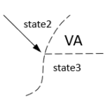
Extreme Geography Virginia has them here.
VA-MD-WV 
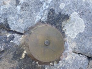
Virginia, Maryland, West Virginia tri-state corner
Bonus! This is also the eastern point of West Virginia.
Coordinates
39°19’17.0″N 77°43’10.1″W
39.321393, -77.719467
Location
Loudoun County Virginia, Jefferson County WV, Washington County Maryland
Access
The tri-state corner is on the south shore of the Potomac River, just north of US340. Maryland owns the river making the tripoint at the south shore of the river.
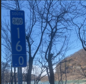
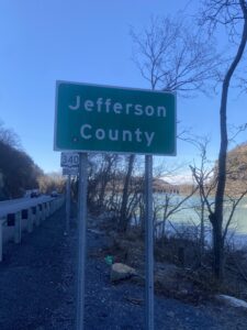
US340 has a wide shoulder on the north side of the road near the Virginia-West Virginia state line. Park on the shoulder near the US340 mile marker 16.0, just east of the Jefferson County sign. Alternately, you can park on the at the gas station about .4 of a mile to the east, at the intersection of US 340 and VA671, cross the road and follow a path on the other side of the guardrail until you reach the US340 mile marker 16.0 sign. The path to the marker is at the 16.0 mile marker.
The path to the marker is very steep. Lots of broken glass, very unsure footing. Not for young kids or people unsteady on their feet.
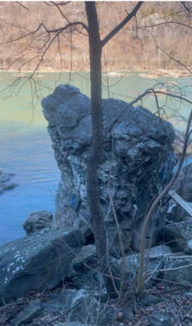
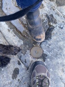
This video was made standing on the marker looking back towards the road
Marker, sign, monument
VA-KY-WV
Virginia, Kentucky, West Virginia tri-state corner
Bonus! on the way you will pass the most eastern point of Kentucky.
Coordinates
37°32’16.7″N 81°58’05.0″W
37.537966, -81.968056
Location
Buchanan County Virginia, Pike County KY, Mingo County WV, near Wharncliffe WV
Access
The tripoint is on the far west shore of Tug Fork. West Virginia owns the river making the tripoint at the VA-KY border at the Tug Fork shore. There are no roads approaching the tripoint from either Virginia or Kentucky. From West Virginia, the tripoint can only be reached by boat or fording the river in dry seasons. Do not attempt to ford Tug Fork unless you are very experienced at river fording. Use the “Good Enough” point!
From Wharncliffe WV follow WV10, Right Fork Ben’s Creek Rd, under the railroad bridge towards the river to a dirt road that runs between the railroad and Tug Fork. (The road to the right it is called Kentucky View and to the left it is Virginia View). Turn right and park. Ford the small channel to a large island and then ford the other channel to the Kentucky side of the river. Follow the river south, bushwacking about a half mile to the tripoint. Bonus – on the way you will pass the most eastern point of Kentucky at about 37°32’33.6″N 81°57’54.0″W.
Marker, sign, monument
The tripoint is on a post with a US Geological Survey marker.
“Good Enough” point
Coordinates
37°32’16.6″N 81°58’00.1″W
37.537941, -81.966689
Location
On Virginia View road, near Wharncliffe WV.
Access
From Wharncliffe WV follow WV10, Right Fork Ben’s Creek Rd, under the railroad bridge towards the river to a dirt road that runs between the railroad and Tug Fork. (The road to the right it is called Kentucky View and to the left it is Virginia View). Turn left and follow the river south about a half mile to the “Good Enough” point. Bonus – on the way you will pass the most eastern point of Kentucky at about 37°32’33.6″N 81°57’54.0″W.
VA-TN-KY
Virginia, Tennessee, Kentucky tri-state corner
You reach this point by hiking the route of the Wilderness Road through the Cumberland Gap National Historic Park, the route first used by Daniel Boone and other Europeans to cross the Appalachian Mountains to Kentucky.
Bonus! This point is also the W, WSW, SW, and SSW point
Coordinates
36°35’17.4″N 81°40’38.6″W
36.588153, -81.677394
Location
Lee County Virginia, Claiborne County TN, Harlan County KY, near Cumberland Gap TN.
Access
The best access point is from Cumberland Gap TN. There is a parking lot at the end of Pennlyn St. The point can be reached by the Tennessee Road Trail, Wilderness Trail and the Tri-State Peak Trail through the Cumberland Gap National Historic Park. Hiking Distance roughly 2.2 miles round trip, 626 feet elevation gain
Marker, sign, monument
Very nice pavilion with monuments
VA-TN-NC
Virginia, Tennessee, North Carolina tri-state corner
This is the highest elevation tri-state point east of the Mississippi River, 4636 feet.
Coordinates
36°36’02.9″N 83°40’31.5″W
36.600811, -83.675408
Location
Grayson County Virginia, Johnson County TN, Ashe County NC. The land approaching the site from all three states is public land. The last parcel to become public was the Divided Mountain tract in Virginia that became part of the Cherokee National Forest in 2019. The approach from North Carolina is through the Pond Mountain Games Lands.
Access
From Virginia
The Tripoint is about 4.5 miles up Pond Mountain Lane, VA755 from its intersection with Whitetop Gap Rd. near Whitetop VA. Please note that as you near the tripoint the road becomes impassable without a 4-wheel drive offroad vehicle. If your vehicle is a street vehicle with 4-wheel drive or all-wheel drive it will not make it! Be prepared to hike the last mile or two.
Access
From North Carolina
The tripoint can be accessed from the Pond Mountain Game Lands, about 20 miles from West Jefferson North Carolina. The entrance is on Rock Fence Road about .7 mile from the intersection with Greer Town Road and Fairview Church Road.
There are two different gates that are opened seasonally that will make big differences in hike length, varying from less than 6 to more than 8 miles depending on multiple options. The entrance gate is generally open from April 1st to January 1st. If the gate is open, you can proceed up the road about 1.5 miles to a second gate and parking. This gate is generally open form September 1st to January 1st. If this gate is open proceed anther mile to the final parking area. From the final parking area, it is about 5.5 miles with a 1300-foot elevation change. Please be aware of hunting seasons and take proper precautions.
Marker, sign, monument
VA-MD-DC (west)
Virginia, Maryland, District of Columbia (west) tri-state corner
Bonus! This is also the western point of the District of Columbia.
Washington DC is not a state, but this this is a true tripoint. There are two locations where VA-MD-DC meet, one to the west of Washington and one to the south. This describes the west tripoint.
Coordinates
38°56’03.6″N 77°07’11.2″W
38.934320, -77.119776
Location
Arlington County Virginia, Fairfax County Virginia, Montgomery County Maryland and Washington, District of Columbia, south shore of the Potomac River
Access
Please note that this location is on private property. Please respect private property and do not trespass. The tripoint is on the south shore of the Potomac River in a steep gorge that is not safely accessible. Maryland and DC own the river to the Virginia shore making the tripoint at the south shore of the river.
Marker, sign, monument
There is a survey marker about 30 feet from the shore that is close to the tripoint
“Good Enough” point, Virginia
Coordinates
38°55’59.4″N 77°07’15.6″W
38.933153, -77.120986
Location
On the road in front of 600 Chain Bridge Road, McLean VA at the border of Arlington and Fairfax Counties.
Access
Very narrow shoulder with no place for long-term parking.
“Good Enough” point, Maryland/DC
Coordinates
38°56’11.2″N 77°07’02.3″W
38.936433, -77.117317
Location
On the Chesapeake and Ohio Canal towpath
Access
In the Chesapeake and Ohio Canal National Park, you can park at C&O Canal Lock 6, 6100 Clara Barton Parkway, Bethesda MD. It is an easy 1.4 mile round trip south to the Maryland-District of Columbia border.
VA-MD-DC (south)
Virginia, Maryland, District of Columbia (south) tri-state corner
Bonus! This is also the southern point of the District of Columbia.
Washington DC is not a state, but this this is a true tripoint. There are two locations where VA-MD-DC meet, one to the west of Washington and one to the south. This describes the south tripoint.
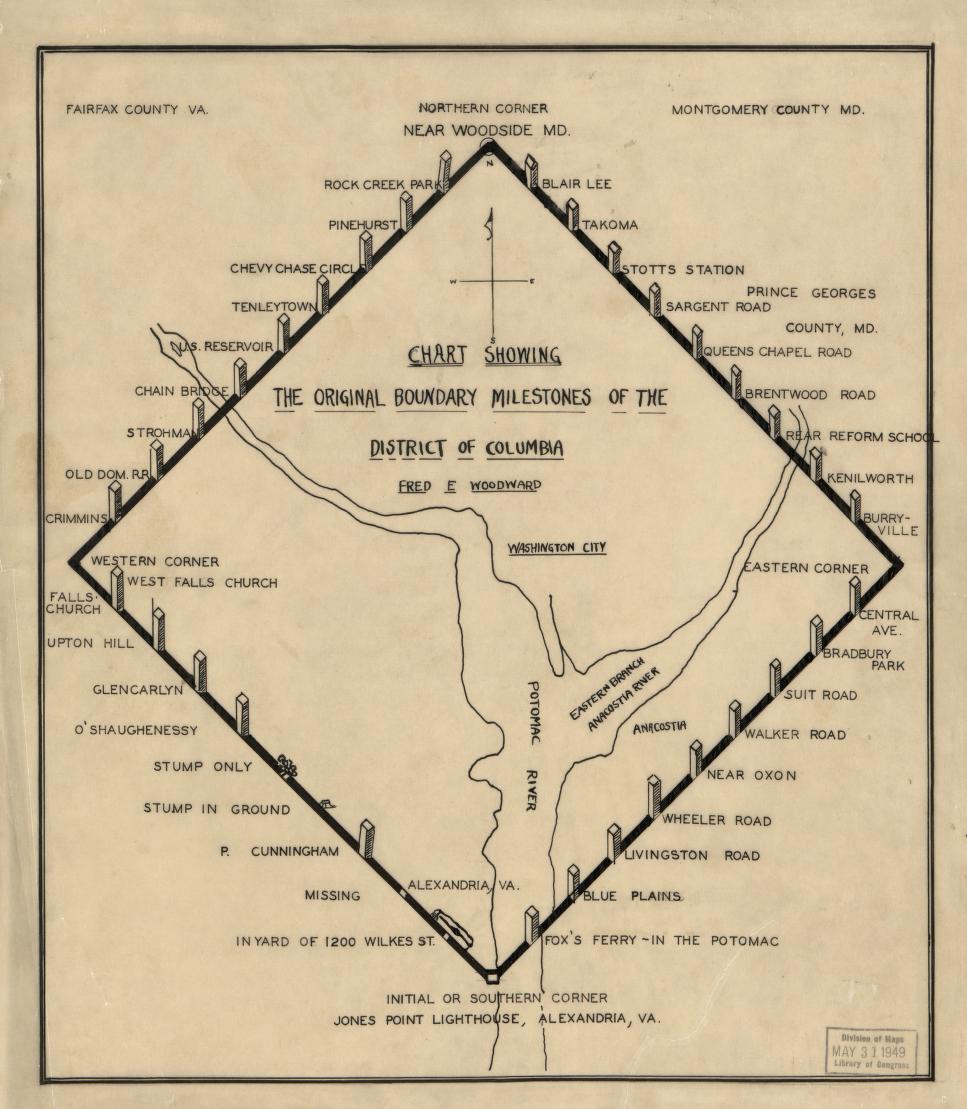
There are two tripoints at the southern end of the District of Columbia, the current tripoint and an historic point. In 1790 the US Government decided the new seat of the federal government would straddle the Potomac River and created the District of Columbia from land ceded by Virginia and Maryland. A square 10 miles on each side was surveyed and marked with 40 boundary stones at one-mile intervals. The southern stone was the first stone and was erected in 1791. The southern marker is the oldest federal monument in the US. It served as the tripoint for VA-DC-MD after Virginia finally ceded its share of the land in 1801 until 1846 when the Congress returned the former Virginia portion of DC back to Virginia. Legally Maryland and DC own the Potomac River to the Virginia shoreline. After the 1846 boundary move, the DC boundary ends at the river shoreline. There are some minor exceptions for small bays and indentations. At either tripoint it is hard to feel that you are also in Maryland and the District, they seem so far away across the wide river.
Current tripoint marker
This point has served as the VA-MD-DC (south) tripoint and the most southern point of DC since 1846.
Coordinates
38°47’29.0″N 77°02’21.8″W
38.791392, -77.039398
Location
Jones Point Park, Alexandria Virginia.
 There are several other boundary markers in the park that marked historic DC-MD and DC-VA boundaries. It can be a little confusing.
Access
Access the park from Jones Point Dr., there is plenty of parking in the park.
You should be parked here:
Walk under the bridge here: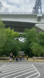
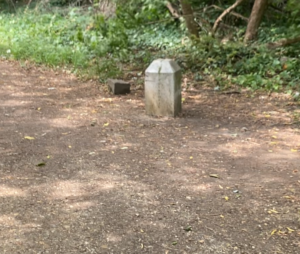
Walk .2 miles south, passing under the Capitol Beltway following the path along the river. When you reach two historic boundary markers that have Maryland and District of Columbia markings on them, backtrack about 50 feet.
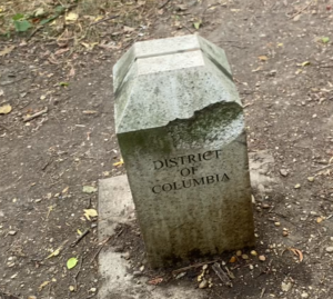
Please note that neither of the markers shown in the photo above are the tripoint, in spite of what other sources may say.
Turn towards the river and pass through the brush to the shoreline. The site is unmarked. The tripoint is actually about 80 feet northeast of this location in the river.
Please note that neither of the markers shown in the photo above are the tripoint, in spite of what other sources may say. They mark the location of the historic DC-MD boundary (yes, not Virginia) that existed from 1801-1846. At that time this area would have been in the river and not dry land. The river shoreline has changed naturally (by storms, erosion and flooding) and by man (this area was a shipyard with factories and docks during WWI).
Marker, sign, monument
None.
Original historic tripoint and marker
This point served as the VA-MD-DC (south) tripoint from 1801-1846 and was the most southern point of DC.
Coordinates
38°47’25.3″N 77°02’26.1″W
38.790355, -77.040579
Location
Jones Point Park, Alexandria Virginia. There are several other boundary markers in the park that marked historic DC-MD and DC-VA boundaries. It can be a little confusing.
Access
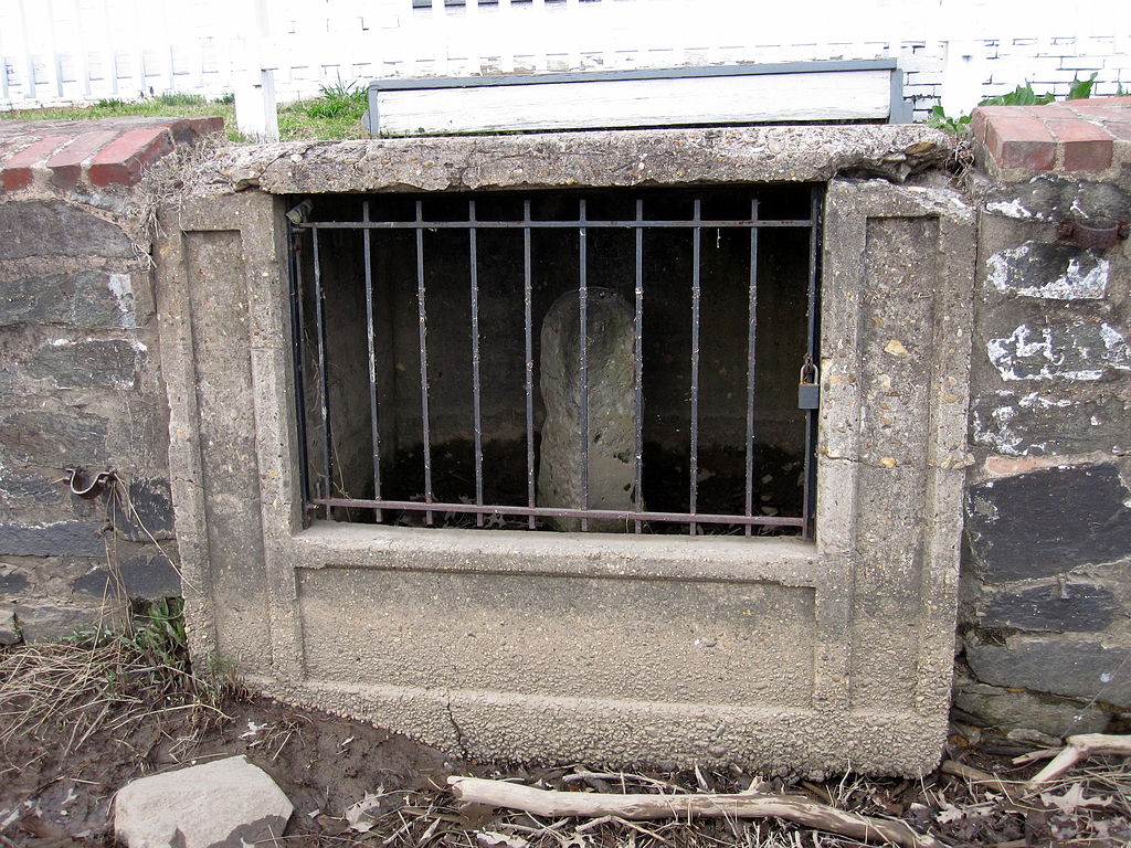
The historic marker is in an opening in the seawall protecting Jones Point Lighthouse. Walk along the path about 450 feet south and then west from the current VA-DC-MD tripoint to the lighthouse. The lighthouse looks nothing like the typical coastal lighthouse and is more like a 19th century house with a light on the roof.
On the side facing the river there is a glass portal on the patio with the monument underneath it. There is another portal in the seawall behind an iron gate.
The top of the patio portal protecting the monument:
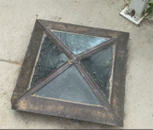
Walking to the river to see the monument.
The river portal protecting the monument looked liked like this when I visited. There is an iron gate, a plexiglass screen and lots of vegetation obscuring the monument. You can’t see much of the monument through it.
This is what the monument looks like when not obscured.
Marker, sign, monument
White, very worn boundary stone in the seawall behind an iron fence .
If you stand at the front of the lighthouse with the lighthouse and river behind you, there are several historic markers in view both to the right and left.
The ones to your right, facing northeast, mark the location of the historic DC-MD boundary (yes, not Virginia) that existed from 1801-1846. The ones to your left, facing northwest, mark the location of the historic DC-VA boundary (yes, not Maryland) that existed from 1801-1846. At that time the DC-MD boundary would have been in the river and not dry land. The river shoreline has changed naturally (by storms, erosion and flooding) and by man (this area was a shipyard with factories and docks during WWI).
© 2023 by Extreme Geography LLC. All rights reserved. Trademark pending for “Extreme Geography”